Landcam 2 Spectra: Preparing a Measurable Multispectral Workflow
Plan Landcam 2 Spectra use through confirmed sensor details, observation goals, aircraft integration, calibration procedures, dataset checks, and practical field interpretation.

Define the purpose before discussing the sensor
Landcam 2 Spectra is one option in NiVO multispectral payload discussions. Begin with the observation need: crop-cover variation, block comparison, land documentation, or patterns requiring field checks. Describe targets, project scale, and intended decisions. The word multispectral does not mean one device answers every agronomic question. Index choice must match the channels actually available and the quality that can be maintained. Clear objectives help the technical team discuss relevant configurations without adding capabilities unconfirmed by documentation or tests of the supplied device.
Confirm the supplied configuration
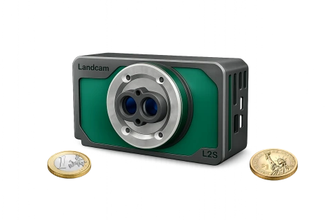
Request the model identity, spectral channels, optical characteristics, file formats, trigger method, and calibration components before specifying the project. Do not fill missing details with numbers from another similar-looking camera. Product photography identifies appearance but does not establish wavelengths, resolution, or georeferencing performance. Retain the agreed configuration documents. Mark unknown parameters as questions and design appropriate tests. This protects recipients from deliverable promises based on assumptions about a system that has not yet been demonstrated in the intended arrangement.
Review aircraft and operator integration
Assess installed mass, dimensions, viewing direction, mount, power, trigger, and storage access together. Additional components affect the system, so body mass alone is insufficient. Confirm that installation clears every optical channel and protects cables from movement. Understand startup, recording, and status indications available to the operator. Approve Landcam integration for the selected NiVO configuration rather than assuming the same installation suits every model. Record inspection responsibilities and the circumstances requiring acquisition to pause for technical review before operational use.
Design the flight around information requirements
Calculate detail and coverage using confirmed optics and image dimensions. Plan overlap, route direction, and blocks around the sensor and processing workflow. Dense canopy can require different attention from richly textured open land. Include terrain, changing cover, and comparison areas. Retain stable block identities in repeated monitoring. A route successful for RGB is not automatically sufficient for multispectral work. A short trial should test coverage and band relationships before the team commits substantial time to a larger collection that may expose preventable limitations.
Establish the appropriate calibration procedure
Understand how illumination and capture settings affect sensor response. Follow the procedure supplied for the actual Landcam configuration. Where panels or light-measurement components are required, document their identities and condition. Do not import coefficients or correction methods from another sensor family without evidence of applicability. Record sky conditions and timing with supporting files. If the procedure is unresolved, limit analytical claims and complete technical confirmation before promising radiometric comparisons across dates. Calibration helps separate vegetation differences from device and acquisition effects.
Check dataset structure before processing
Inventory files for each capture and available channel after flight. Check names, timing, position metadata, and calibration records. Copy originals before conversion or processing. Preserve relationships where the device records paired or associated files. Inspect samples from the start, middle, and end for missing channels, unsuitable exposure, or declining sharpness. Field checks leave the option of repeating affected areas while access and comparable conditions remain available. Completeness is a prerequisite to discussing indices or the quality of the final reconstructed products.
Define geometric and spectral processing
A multispectral map must preserve spatial relationships between channels so an index does not combine different objects. Inspect edges of vegetation, roads, and high-contrast features. Confirm that the software supports the device's files and metadata. Document correction, conversion, and alignment parameters. Keep display enhancements separate from analytical values; contrast adjustments useful for presentation must not silently change measurement inputs. Review seams when combining blocks and explain differing acquisition conditions before treating the whole area as a uniform analytical dataset.
Connect image patterns with field observations
Use maps to formulate inspection questions rather than diagnose every color difference. Visit several patterns, including relatively stable comparison areas. Record crop type, age, soil cover, water conditions, and known management events. Check that any selected index uses channels genuinely supplied and appropriately processed. Do not transfer thresholds from another site without testing their meaning. The useful outcome is a traceable relationship between aerial observations and field evidence, allowing managers to identify follow-up areas and understand what the available data still cannot establish.
Make project acceptance verifiable
Agree sample outputs and acceptance criteria with NiVO and the recipient before full-scale work. A trial package can include originals, channel completeness, coverage, calibration information, and alignment checks. State whether the product supports within-flight interpretation, comparisons over time, or another purpose with additional requirements. Retain tested settings and identify later changes. Bring examples and project questions to consultation. This makes Landcam 2 Spectra part of an evaluated workflow without inventing specifications or promising conclusions beyond the evidence the selected configuration can support.
Illustrative case: resolving an unconfirmed Landcam configuration
Consider a hypothetical project brief that requests a vegetation index from a Landcam 2 Spectra payload but lists no confirmed channel definitions, output format, or calibration procedure. A team member proposes filling the gaps using specifications from a similar-looking camera. The technical lead pauses that assumption and creates a confirmation sheet for the actual supplied unit. The sheet requests model identity, optical information, channel relationships, triggering, file structure, and required supporting references. The project question remains unchanged, but the method is not promised before those inputs are known.
Once configuration information is available, the team designs a small trial that follows files from capture through copying, band association, processing, and a sample analytical output. The reviewers check whether channels align at vegetation boundaries and whether the available correction workflow supports the intended comparison. Missing information is documented rather than disguised through display adjustments. If the trial only supports relative interpretation within one visit, the report states that boundary and avoids promising comparable values across seasons. The acceptance record includes source files and unresolved questions. This hypothetical scenario makes consultation more efficient by separating confirmed capability, integration testing, and analytical ambition instead of treating the sensor name as a complete project specification.
The decision compares a limited demonstration of useful within-visit patterns with a stronger promise of measurements comparable across visits. Those are different deliverables, not alternate marketing descriptions of the same evidence. Handover requires a configuration sheet tied to sample files and a processing explanation that another person can follow. If essential metadata or calibration relationships are unavailable, the contract scope is clarified before a larger survey is sold. The retained trial also identifies which unknowns were resolved and which remain, keeping later equipment changes from being mistaken for an already accepted capability.