Using Point-Cloud Tile Buffers to Control Edge Artefacts
Process tiled point clouds with enough surrounding observations for neighbourhood operations, then trim outputs consistently and test seams against an untiled reference.
Recognise a computational boundary
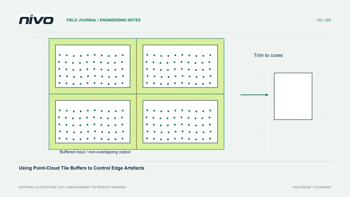
A tile edge is usually a storage decision rather than a physical feature. Ground classification, interpolation, normal estimation, and local statistics can nevertheless react to it when neighbouring observations are missing. A regular checkerboard pattern in the output may therefore reveal processing boundaries rather than terrain. Investigate whether the operation saw enough surrounding data before trying to smooth the final seams away.
Identify the operation's neighbourhood
Review the algorithm's spatial support: a fixed search radius, a moving window, a nearest-neighbour count, or a sequence of operations with expanding influence. A buffer suitable for one stage may be insufficient for another. Sparse areas can require a wider search than dense areas. Select the margin from the documented method and a representative comparison, rather than a universal distance copied between projects.

Read a buffer but retain a core
Distinguish the buffered input extent from the core area assigned to a tile's final output. Read surrounding points, perform the required calculation, and then retain only the agreed core result. Keep the tile origin and dimensions consistent across stages. If the algorithm carries information beyond the chosen margin, consider larger processing blocks or another workflow instead of assuming a small buffer guarantees equivalence.
Prevent duplicate final observations
Neighbouring buffered inputs deliberately share observations, but their final cores should follow an explicit ownership rule. Otherwise merged outputs can contain duplicated points or conflicting raster cells. Inspect boundary inclusion conventions and ensure that shared edges are assigned consistently. Preserve point identifiers or other suitable traceability where available so accidental duplication can be distinguished from genuine overlapping acquisition observations.
Compare seams with a larger reference
In a hypothetical hillside terrain project, select a test area spanning several tile junctions and process it once as a larger block. Compare the tiled and larger-block results along seams, around sparse vegetation gaps, and at sharp terrain changes. Increase the buffer or revise the processing sequence when differences affect the intended interpretation. A smooth overview alone is inadequate evidence of equivalence.
Record the tiling contract
Deliver the tile index, core extents, buffer policy, processing settings, and seam-check results with the dataset. State whether supplied files contain buffered observations or final nonoverlapping cores. Acceptance should establish complete coverage, controlled duplication, and acceptable local agreement for the chosen use. These checks address computational edge effects; they do not replace classification review, strip alignment, or independent survey accuracy validation.